|
|
 |
|
|
The Piéla-Massako Permit/Burkina Faso - Summary Report
|
|
|
|
Original report by W. Hampel (1997): 68 pages, 55 figures/maps, 13 tables and 6 annexes
|
|
|
|
|
Client: Emerging Africa Gold Corporation, Montreal
|
Position held: General Manager Burkina Faso
|
|
|
|
|
The initial aim was to delineate an oxidized, open-pittable gold resource of at least 1 mio. ounces with a minimum GT-value of 100. The minimum target was later augmented to
2 mio. ounces.
|
|
|
|
|
+ Installation of a permanent field camp
|
+ evaluation of all known orpailleur workings
|
|
+ compilation of all available data
|
+ statistics of soil geochemistry
|
|
+ regional mapping , 1:50,000, 780 sqkm (Landsat interpret.)
|
+ detailed struct. and geol. interpretation of the permit
|
|
+ prospect scale mapping, 1:5,000, 15 sqkm
|
+ description of known mineralisation
|
|
+ soil/lag/termite mound geochemistry (Au+33), 4,000 samples
|
+ development of metallogenetic models
|
|
+ outcrop sampling, 400 samples
|
+ description and classification of targets
|
|
+ ground geophysics, 25 line kilometers (VLF, MAG, IP)
|
+ description of methodology
|
|
+ 580 m trenching, with detailed logging and sampling
|
+ proposition of detailed 1-year work program
|
|
+ RC drilling, 4,000 m, 80 holes
|
+ proposition of a 1-year US $ 1,050,000 budget
|
|
|
|
|
|
|
|
|
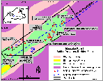
The 780 sqkm are almost entirely underlain by volcanic and volcanosedimentary sequences of Birimian age. The compositions of the metavolcanics range from intermediate to felsic, mafic to
ultramafic lithologies are less abundant. The Birimian rocks are embedded in Archean gneisses and migmatites. Eburnean metagranites and metagranodiorites are frequent
in the N, S and W. Mesozoic dolerite dykes crosscut the area with N115. A cluster of airborne detected magnetic anomalies in the SW are interpreted as possible kimberlites. At least three different stages of extensive duricrust formation are known.The Birimian sequences are intensely folded and faulted. Metamorphism reaches lower greenschist facies. A major shear zone crosses the permit along its longer axis, shorter, secondary shear zones are +- parallel. Two major deformation zones, the Basieri and Madyabari 'corridors' were identified during the field campaign. They host the majority of all gold showings.
|
|
|
|
|
|
|
|
In total 21 targets for gold, base metals and diamonds were identified. Most of the gold showings belong to the narrow vein type, though some are very high grade (up to 250 g/t Au over 0.50 m) and
show considerable host rock mineralisation.
Reconnaissance drilling on a 2,800 m x 250 m gold in lag anomaly returned very encouraging results with 11 m @ 5.99 g/t, 10 m @ 2,39 g/t and 22 m @ 1.24 g/t. This anomaly lacks any outcrops. Trenching points to a high-grade stratabound mineralisation in metacherts and andesitic tuffs. Many anomalies stayed 'untouched', as for example a strong Pb-Zn-Ba-anomaly that was discovered during a regional lag survey.
|
|
|
|
There is a fair number of prospects that could yield in excess of 200,000 oz gold each. Since 1997, the permit holder Mr. Dô Konaté has been conducting successful small-scale mining
operations (gravity treatment of high-grade orpailleur rejects).
|
|